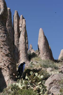
I just want to make sure that no one starts thinking that the Superstitions are a great place to mountain bike. The Superstitions (Superstition Mountains) -- commonly called just "The Sups" -- are designated wilderness under the 1964 Wilderness Act -- meaning , 1. Most vehicles are not allowed. It's quite severe, steep and extreme, 30 lbs of food and water would be a better choice to carry than 30 lbs of bike. It's a great place for the uninitiated to get lost and die, or seriously hurt, but it's not the best choice to ride. I seriously suspect that the most commonly used vehicle in the Sups is the helicopter, but it might be the gurney with the wheel. Elevations vary from 1500 to 4500+ feet and weather and potential for illness due to exposure are signifigant every day. There are fairly permanent sources of water at Charleybois and Second Water -- and Hackberry Springs, but I would never rely on them. I have a lot of wildeness experience, and every time I go in to the Sups, I come out in pain. I've been disoriented, run out of water, become overheated, and survived. Be careful, carry a map and compass, water, and file a trip plan with a trusted friend. It's really verticle.
If you want to know more about what a wildernes designation means -- try this.
Personally -- I believe that the designated wilderness areas should be vehicle free -- however -- I am a lot more benevolent toward snowmobiles than any other form of wilderness transport, except snowshoes or skis. This is primarily because the footprint is going to melt -- so damage is very minimal. In the same vein I am tolerant of ATVs in sand dunes -- because the footprint is (for the most part) transitory. I am particulary unfond of the noise these vehcles make, and the permanent damage that ATV's do in other parts of the desert.
There are large tracts of opportunity for vehicular travel in the National Forests, National Parks and other less than wilderness areas.
Hwy 60 rolls through the superstitions to Globe. It's a beautiful winding drive through a tight dramatic canyon littered with roadside crosses. It looks dangerous to me -- but might make for a nice road trip on a bike or in a 57 T-bird.
13 comments:
Great pic, great post. I always thought it was funny I could take a radio into a wilderness, but not a cd player. I agree about he snowmachines - their impact is small, but the rules are the rules and I hear that up in Alaska they have no problem confiscating snowmachines.
I am just a little benevolent. They are really tolerable when they give you a ride.
Indeed. Great post and pictures. By the way, your snake picture the other day reminded me – AGAIN – why I should always have my camera with me, with batteries, that is. I never learn.
Shawn, I think from primarily a roadies point of view, so I was referring to a road bike ride through the Sups. Here's a loop I'd like to ride, for example (with support!)
http://www.ajpl.org/images/routemap.gif
This is the "Apache Trail Circle Route".
zewybiktI think the pavement may end there at Tortilla Flat -- I think that you will join the legion of gravel roadies at that point. Nevertheless, I hear the chili at Tortilla Flats is worth the spin out there.
"President Teddy Roosevelt described the route as 'one of the most spectacular, best-worth-seeing sights in the world.' It's a gem no matter what time of year, although late summer can pose extra hazards from monsoon rains and washouts. The drive is doable by passenger car, but is best done in an SUV. The descent down a narrow gravel road into Fish Creek Canyon is one you'll never forget, and is guaranteed to scare the wits out of Aunt Minnie from Queens. Your guests may want to slit your throat before you reach historic Roosevelt Dam, but by the end of the day they will sing your praises for taking them on the drive of a lifetime." Source, The Pheonix New Times.
It sounds like a great ride Tom. You can do it self-supporting -- but it might be a bit scary. Spend about two weeks doing it and hike into the Superstition Wilderness every day and camp!
Alberto and John -- Thanks!! We had a viscious dust storm today -- and guess what -- no camera. Poop!
What a beautiful place. I'd love to visit someday. With 30 pounds of water.
I have 10 liter bladder (that's 22 lbs -- or half my body weight) ... which I never use. There is often good water and Reavis Falls is taller than parts of Niagara Falls.
Jill -- you and your "running guy" boyfriend Geoff -- could manage fairly well in there.
The Superstition Ridgeline hike -- if you looked at the pictures -- is 11 miles + one mile up and one mile down. Alledgedly it is as tough as a rim to rim Grand Canyon hike. I still hurt and it's been 7 months.
If you ever go -- feel free to ask me -- and I will try to help. I know some really nice hikes and I have details.
HikeAZ.com has great descriptions and maps.
Sounds like I'll need to ride the fat tire bike then!
I've twice done 5 day solo backpacking trips in the Sups. Between the 2 trips, I covered about 130 miles. Once was in January and the other time in February. That time of year it is the perfect escape from the snow and cold of Colorado but I don't think I'd want to be there in the summer. It's really an amazing area.
I carry 1 gallon of water and if I find water and I've only used a pint I still refill. I have had to hike longer than I wanted because I couldn't stop for the night without getting to a water source.
Cool Rob. I want to get back in there. My last trip in was the 5 mile Hackberry springs loop, which travels in a creek bed for some distance. I find this open creek bed travel to be extremely painful. But it went much better than the previous trip.
I have hiked the Sups in the Summer -- and it's much better to hike in the early day. Last year on July 2nd I did the bluff springs loop (11 miles). It was 109 degrees as we left at about 11:00 AM.
I carry one liter per hour hiking (2-3 miles) plus one liter per day, in case something happens, and I have to stay. When the daytime temps are over 100, I don't like to solo.
Although I haven't actually done any multiple day trips in the Sups -- My experience on a multiple day trip in Joshua tree in June tells me that multiple day trips are harder because you have to find shade for the hotter part of the day and keep cool without A/C or running water. In the open areas of the desert it can be hard to find enough shade to get out of the direct sun -- So I always try to target a location with known shade to weather out the hotter part of the day.
I always file a trip plan with a friend when I go into the Sups. And I never do 8 miles away in the Usery Mountain Park. The trails are well defined in the park and the routes tend be heavily traveled and shorter.
Ooooo, Hoo Doos!
At least - looks like Hoo Doos I saw in Banff National Park.
Love them hoo doos. Who do? I do.
Those are the oh soo hoo doo hoodoos. I love those whodoos.
Post a Comment